After a few decades involving many mergers and name changes, the New Castle & Franklin Railroad become part of the Pennsylvania Railroad system (later Penn-Central and Conrail). Details of these transactions may be found here. With the decline of the railroad industry following World War II, side spurs to the mainline Pennsylvania Railroad, such as this original trackage became less and less important. The last train to use the original New Castle & Franklin right-of-way ran in the 1970's . The tracks remained in place for many years before being removed.
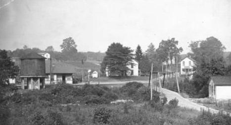
Since the rails were only removed relatively recently, traces of the original railbed are easily seen from both the ground and from the air. The railbed enters Mercer County just north of Volant on the western side of Neshannock Creek. From there, it proceeds north past Leesburg Station (seen in the photo above), following Neshannock Creek and crossing US 19 just north of the Iron Bridge. Continuing northward, the railbed passes through the now tiny village of Hope Mills before crossing Interstate 80. It goes through the eastern end of the county seat of Mercer, where it splits into two branches just north of East Market Street (Scrubgrass Road).
One branch follows Otter Creek in a northerly direction, where it eventually links up with the northbound B&LE Railroad (originally the Shenango & Allegheny), the other follows a more or less easterly path, where it splits again into two branches: one continuing to the east where, it too, links to the B&LE but in a southbound direction, and the second one, the mainline, follows Cool Spring Creek to the northeast, eventually deviating slightly to the east into Jackson Center where it crosses US 62, proceeding toward the north.
In this last leg of the original New Castle & Franklin Railroad, there are side spurs off of the original railbed that apparently once served the local coal mines. These are visible in both aerial photos as well as topographical maps of the area. However, from here north, any indications of the original railbed tend to fade in and out of the largely agricultural landscape and modern infrastructure. In fact, for a brief distance near Stoneboro, a road has been constructed over the original railbed. Just north of Stoneboro, near a place listed on older maps as Coulson Station, the railbed is seen to loop to the northwest and then back to the southeast, where it connects with the old Jamestown & Franklin Railroad (later the New York Central, Penn Central, and Conrail).