Further to the southeast, we pick up the trail again in a less developed area just south of Morefield Road. Though probably not too apparent to the observer on the ground, aerial photos reveal meager but clear traces of the original railbed as it loops back to the east, intersecting Keel Ridge Road just south of the now tiny village of New Virginia. The original Virginia Station still exists as a residential dwelling at 1220 Keel Ridge Road. Originally known as The Rollinson Store, it served as the railroad station for most of the railway's existance.
To the east of Keel Ridge Road, the orginal railbed becomes quite prominent in aerial photos, especially the presence of a switch just south of Virginia Road, where a spur proceeds eastward toward the village of Neshannock and the mainline railway loops southeastward again. The eastern spur splits once more just west of Neshannock, into one proceeding northeastward and one maintaining its eastern path, both ending at the location of old coal mines. The mainline railbed is clearly visible in aerial photos from here south to a point where it loops back to the east once more.
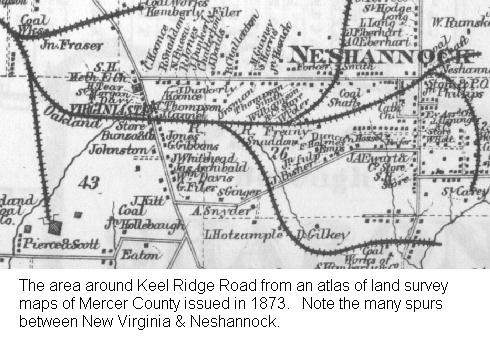
The map shown above shows a portion of a land survey map of Mercer County issued in 1873. Many of these maps may be obtained here. It shows that the mainline railway ends near present-day Neshannock Road, just north of the village of Bethel. However, eventually the mainline was completed southward along the West Branch Little Neshannock Creek (sometimes locally referred to as Carbon Creek, obviously another coal mine reference) into Lawrence County through the town of New Wilmington and linked with the New Castle & Franklin Railroad at Neshannock Falls. This stretch of the old railbed appears quite prominently in the aerial photos.
As coal mining in the western part of the county waned into the twentieth century and the valley towns of Farrell, Sharon, and Sharpsville became great steel production centers, the rail line remained open, operating simply under the name Sharpsville Railroad (sometimes referred to as the Sharpsville-New Wilmington Railroad). Finally, the rail line ceased operations at the end of 1932 (supposedly another victim of the Great Depression).